

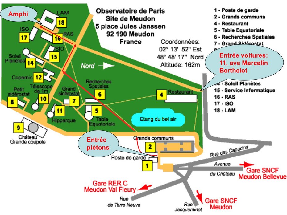
MAP OF MEUDON SITE
HOW TO REACH MEUDON SITE
Access by car fromParis:
- From "Boulevard périphérique" (ringroad around Paris): take the exit Quai d’Issy, then the directions "Issy les Moulineaux, Sèvres", thereafter "Meudon".
- From RN 118 (highway connecting to Boulogne): from Pont de Sèvres, take the direction Chartres Orléans, leave at exit Meudon,Sèvres" then take the direction Meudon.
Access by train:
At Gare Montparnasse in Paris, take the suburban train ("transilien") with destinations Sèvres Rive Gauche or Versailles-Chantiers, Rambouillet, Chartres, etc.... Make sure on the platform that the train stops in Meudon or Bellevue.
3rd stop: Meudon (after Vanves-Malakoff and Clamart). Leave the train building, take the street on the right (Rue Claude Dalsème), continue about 200 metres, take the street towards the right, then straight ahead and uphill towards the pedestrians' entrance of the observatory, 5 Place Jules Janssen.
4th stop: Meudon-Bellevue. Leave the station building towards the left, slightly uphill. At the crossroards, continue essentially at 180° (avenue du Château), uphill to the pedestrian's entrance of the observatory.
The walk is about 15 minutes. You'll need 5-10 further minutes inside the observatory to reach building 18.
Access by RER train:
Take train line RER-C connecting central Paris (Notre Dame, Tour Eiffel …) with Versailles Rive Gauche. Get offet at Meudon-Val Fleury station. Leave the platform using the escalators, at the top turn left towards Meudon. Choose the street with the steepest ascent (Rue Banès). Continue uphill, always following the streets with the steepest ascent: Rue de Paris, Monoprix supermarket on your left, cross the street, Rue Terre Neuve. Lt will take you 20 minutes to reach the pedestrians' entrance of the observatory.
Access by Underground (Métro) and bus:
Metro line 12, at Mairie d’Issy Metro station: take bus line 169 with destination Pont de Sèvres. Get off at stops Place Rabelais or Église de Meudon.
Metro line 9, at Pont de Sèvres terminal station: take bus line 169 with destination Hôpital européen Georges Pompidou. Get off at stops Place Rabelais or Église de Meudon.
From either of these stops, walk uphill (via Avenue Jacqueminot from Place Rabelais, via Rue Terre Neuve, opposite to the Monoprix supermarket, from Eglise de Meudon) during about 5-10 minutes to get to the pedestrian's entrance of the observatory.
Coordinates
Longitude : 2 ° 14’ East - Latitude : 48 ° 48’ North - Altitude : 162 metres